

How to Read a Mutation Survey Map Like a Pro
If you’ve ever looked at a mutation survey map and felt confused by lines, numbers, and symbols, you’re not alone. These maps can seem technical, but once you understand the basics, they become powerful tools for verifying land ownership, boundaries, and subdivision details.
In Kenya, mutation maps are critical in land transactions because they show how a parcel has been subdivided or altered and form the basis for updating land records.
This guide will help you read a mutation survey map like a professional investor or surveyor.
1. What Is a Mutation Survey Map?
A mutation survey map is a technical drawing prepared by a licensed surveyor that shows changes made to a parcel of land.
These changes include:
- Subdivision into smaller plots
- Boundary adjustments
- Combination of parcels
- Redistribution of land among owners
Once approved, the mutation updates official land records and supports issuance of new titles.
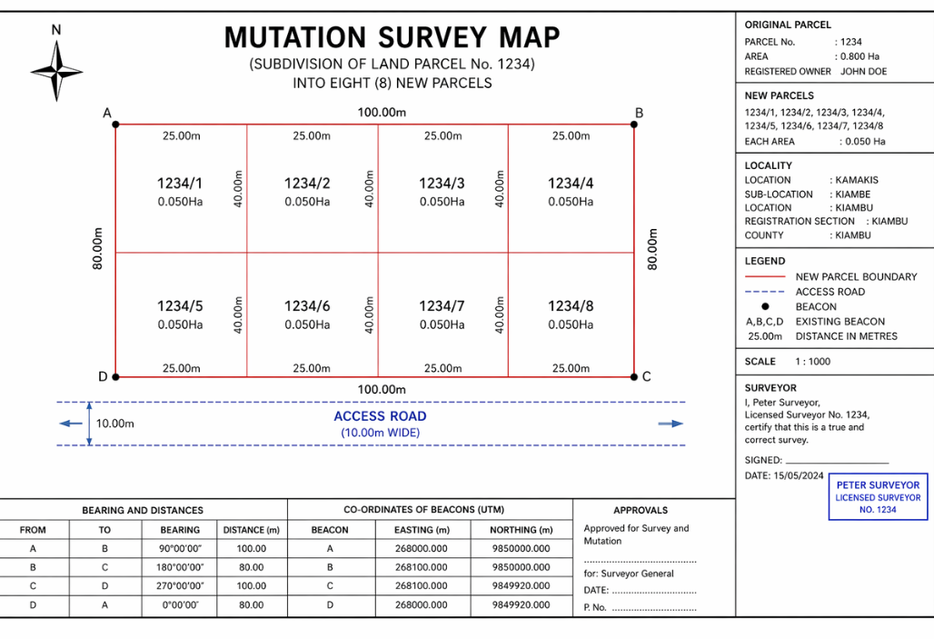
2. Start with the Title Block (Top Section)
The title block is usually at the top or corner of the map and contains key identification details.
Look for:
- Original parcel number (mother title)
- New plot numbers (subdivisions)
- Location/registration section
- Surveyor’s name and license number
- Date of survey and approval
This section tells you what land is being changed and where it is located.
3. Understand Parcel Numbers and Subdivisions
One of the main purposes of a mutation map is to show how land is divided.
- The original parcel is often labeled clearly
- New plots are assigned new numbers (e.g., Plot A, B, C or 1234/1, 1234/2)
- Each new parcel is clearly outlined
Mutation maps are essential because they formally document how land is subdivided and recognized by the land registry.
Pro tip: Always confirm that the plot you’re buying matches the new parcel number, not the original one.
4. Read the Boundary Lines Carefully
Boundary lines define the exact shape of each plot.
You’ll typically see:
- Solid lines → confirmed boundaries
- Dashed lines → proposed or previous boundaries
- Corner points (beacons) → marked with symbols or coordinates
These boundaries are critical because they determine ownership limits and prevent disputes.
5. Decode Measurements and Dimensions
Every side of a plot will have numbers showing:
- Distance (in meters)
- Bearings (direction of the boundary)
For example:
- 25.0m = length of that boundary
- Bearings like 90° or NE indicate direction
Survey maps rely on precise measurements and coordinates to define land size and shape accurately.
Pro tip: Add up the dimensions to confirm the total area matches what is being sold.
6. Check the Plot Size (Area)
Each subdivided plot will have its area indicated, usually in:
- Square meters (sqm)
- Hectares (ha)
Example:
- 0.05 Ha = 1/8 acre (approx.)
Always verify:
- Does the size on the mutation match the size in the sale agreement?
- Is the size realistic based on the map dimensions?
7. Identify Access Roads and Easements
Mutation maps also show infrastructure such as:
- Access roads
- Footpaths
- Wayleaves (e.g., for power lines or drainage)
These are extremely important because:
- A plot without access may be legally unusable
- Easements may limit where you can build
Pro tip: Ensure your plot has clear road access shown on the map.
8. Look at Neighboring Parcels
A mutation map doesn’t exist in isolation, it shows surrounding land.
You’ll see:
- Adjacent plot numbers
- Neighboring boundaries
- Nearby roads or features
This helps you understand:
- The location of your plot
- Whether boundaries align with neighboring land
9. Confirm Surveyor and Government Approval
A valid mutation must be signed and approved.
Look for:
- Surveyor’s signature and stamp
- Government survey approval
- Land registrar endorsement
Mutation forms involve multiple parties including surveyors and land registrars to ensure accuracy and legality.
No approval = not legally valid.
10. Match the Map with the Ground (Site Visit)
Never rely on the map alone.
Visit the land and confirm:
- Beacon positions match the map
- Plot shape aligns with what is drawn
- Roads and access exist physically
Survey maps are accurate but only when properly implemented on the ground.
11. Common Mistakes to Avoid
- Ignoring access roads
- Buying based on the “mother title” instead of subdivision number
- Not verifying beacon positions
- Assuming all boundaries are accurate without a surveyor
12. Why Mutation Maps Matter in Land Buying
Mutation maps are not just technical drawings, they are legal proof of land changes.
They help:
- Prevent boundary disputes
- Confirm subdivision legality
- Support title deed processing
- Ensure accurate land records
Without a mutation, land changes cannot be officially recognized in the registry.
Conclusion
Reading a mutation survey map is a critical skill for any land buyer or investor.
Key Takeaways:
- Start with the title block for identification
- Understand parcel numbers and subdivisions
- Check boundaries, measurements, and area
- Verify access roads and neighboring plots
- Confirm approvals and match with the ground
The more you understand the map, the less you rely on guesswork and the safer your investment becomes. In land buying, knowledge is not just power it’s protection.