

The Difference Between RIM Map and RF Map in Kenya: A Complete Guide for Land Buyers & Investors
When buying land in Kenya, understanding survey maps is critical for safe land investment, due diligence, and avoiding disputes. Two commonly mentioned maps are the Registry Index Map (RIM) and the RF Map (Registry File / Fixed Boundary Survey Map). Many investors confuse the two yet they serve very different purposes in land registration and boundary verification.
This guide explains the difference between RIM maps and RF maps, their legal meaning, accuracy levels, and when each should be used.
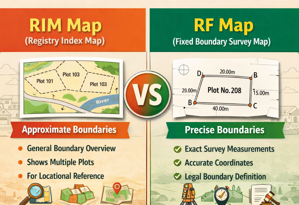
What Is a RIM Map (Registry Index Map)?
A Registry Index Map (RIM) is an official cadastral map used in land registration to show multiple land parcels within a specific registration area. It is widely used across Kenya, especially for land registered under the Registered Land Act system.
Key Features of a RIM Map
- Shows several plots within a region on one map sheet.
- Indicates approximate boundaries and parcel locations.
- Used mainly for general boundary land registration.
- Helps identify surrounding parcels, roads, and subdivisions.
RIM maps are based on “general boundaries,” meaning the boundary positions are approximate rather than exact measurements.
They are mainly used for:
- First land registration
- Locating plots in an area
- Subdivision planning
- General land management
The Ministry of Lands notes that RIMs help show all parcels within an area and assist in monitoring changes and preventing fraud.
What Is an RF Map (Registry File / Fixed Boundary Map)?
An RF Map (often linked to fixed boundary survey plans or cadastral survey maps) represents land surveyed with precise measurements. These maps are derived from detailed surveys and are typically used for land registered under systems requiring fixed boundaries.
Key Features of RF Maps
- Provide accurate measurements of land boundaries.
- Include beacon positions and exact survey coordinates.
- Used in high-value urban or commercial land.
- Essential for precise construction or development projects.
Unlike RIM maps, RF maps are based on fixed boundary surveys, meaning the parcel boundaries are determined using exact linear and angular measurements verified by professional surveyors.
Major Differences Between RIM Maps and RF Maps
1. Boundary Accuracy
- RIM Map: Shows approximate boundaries (general boundary system).
- RF Map: Shows precise, fixed boundaries with exact survey data.
2. Purpose
- RIM Map: Used for land identification and registration overview.
- RF Map: Used for legal boundary confirmation and development planning.
3. Level of Detail
- RIM Map: Covers many parcels in one area.
- RF Map: Focuses on a single plot with detailed measurements.
4. Survey Method
- RIM Map: Based on general boundary surveys.
- RF Map: Based on accurate cadastral or fixed boundary surveys.
5. Legal Precision
- RIM Map: Useful for reference but not exact boundary positioning.
- RF Map: Used in legal disputes requiring precise boundary determination.
When Should You Use a RIM Map?
A RIM map is useful when:
- You want to locate land before buying
- Checking nearby plots and infrastructure
- Understanding neighborhood layout
- Reviewing subdivisions
Since RIM maps display multiple parcels, they provide a big-picture view of an area and surrounding developments.
When Should You Use an RF Map?
An RF or fixed boundary survey map is essential when:
- Constructing buildings or fences
- Confirming exact land size
- Solving boundary disputes
- Developing commercial or urban land
For precise investment decisions, many professionals recommend combining both maps during due diligence.
Why Land Investors Must Understand the Difference
Confusing a RIM map with an RF map can lead to:
- Boundary disputes with neighbors
- Construction on the wrong land
- Legal challenges during title transfers
Since RIM maps only show approximate parcel positions, relying solely on them for development planning can be risky. Accurate RF maps provide the precision required for major investments.
Final Thoughts: RIM Map vs RF Map
In Kenya’s land system, both maps play vital but different roles:
- RIM maps help investors understand land location and surrounding parcels.
- RF maps provide the exact boundary measurements required for legal certainty and construction.
For safe land investment, always conduct professional surveys and review both map types during due diligence.